
Monterey County
Monterey County
A large and diverse geographical area, Monterey County is located about an hour south of the famed Silicon Valley. Part of California’s Central Coast, the County is a special place endowed with a magical coastline. Monterey County's coastal influence from the rugged Pacific Ocean is just one of many unique aspects which contribute to rare and unparalleled grape-growing attributes.
Monterey County's primary winegrowing region is found within the Salinas River Valley. With dramatic mountain ranges to both the East and West, the Salinas Valley includes many prominent American Viticultural Area(s) (AVA), including the Arroyo Seco AVA. In general the winegrowing region benefits from an arid climate as well as direct exposure to the Pacific Ocean. Of course what makes Monterey County different from other appellations, and thereby special, is the rarity of dramatic geographical conditions:
Positioned north-to-south, the Salinas River Valley begins at Monterey Bay and the Pacific Ocean. A direct and unobstructed corridor from the ocean, the valley is considered an Open Throat. The unique “open” geography creates a Thermal Rainbow, whereby as one moves south away from Monterey Bay the temperature rises dramatically. The Thermal Rainbow effect is heightened in Monterey County because of a very rare and relatively unknown, subterranean trench found just offshore at Monterey Bay.
Monterey County's 'Blue Grand Canyon' & the 'Thermal Rainbow' - Image Courtesy of MCVGA.
The 'Blue Grand Canyon' is a very deep marine canyon similar in size and scope to the Grand Canyon. Not necessarily apparent above water, the deep underwater canyon affects the level of regional cooling; the saturation and penetration of fog as well as the strength of winds that sweep through the Salinas Valley. The result of this rare geographic condition is extreme cooling and regional temperature variances, all of which contribute to the uniqueness of Monterey County as a grape growing region.
Another rare condition found in Monterey County’s Salinas Valley is a north-south orientation. Unlike most other marine-influenced river valleys and wine growing regions, which are oriented east-west, the Salinas Valley is bifurcated from the Pacific Ocean to the west by the Santa Lucia Mountains. This natural geographical boundary creates a Rain Shadow that impacts the region and contributes to its semi-arid nature. The Rain Shadow contributes to the Salinas Valley generally receiving less than 10 inches of rain per year. The arid conditions result in increased stress on the vines, diminished yields, as well as stimulating root growth into different subsoil zones.
Ultimately, the combination and effects of Monterey County's many rare geographical conditions manifests in the vineyard to produce high quality grapes with unmatched character. To learn more about Monterey Wine Country please visit the Monterey County Vintners and Growers Association (MCVGA) by clicking here.
Arroyo Seco AVA
Arroyo Seco AVA
An American Viticultural Area (AVA) is a designated wine grape-growing region in the United States distinguishable by geographic features, with boundaries defined by the Federal Government.
Monterey County, CA
The Arroyo Seco AVA encompasses portions of two towns; Soledad and Greenfield in California's Monterey County. In the rural, western extremes of these townships the Santa Lucia Mountains rise dramatically, creating the western boundary of the Salinas Valley, and provide the unique setting for one of California's earliest recognized viticultural area. It is in this landscape that a transverse waterway from the mountains carved the distinct geography and geology, and ultimately converges with the maritime influences of the deep, cold waters of the Pacific Ocean found 40 miles north at Monterey Bay. Ultimately, the confluences of so many distinct geographic factors unite to form this small, finite growing region.
Granted federal AVA status on April 15, 1983, the Arroyo Seco appellation is steeped in winegrowing history and rooted in the geographic features of a waterway named "Arroyo Seco". This seasonal creek brings rain water and snowmelt from the Santa Lucia Mountains and the Los Padres National Forrest to the Salinas Valley. Over the millenniums the pressure of this natural water-release created a diverse geography; carving landscape, dumping rocks and filling a deep subteranian aquifer with clean, pure water. Ultimately, the esteemed authors of the appellation cited the unique terrain formed by the Arroyo Seco as the foundation of AVA's boundaries. Within the AVA's boundaries the first commercial vineyard, Mission Ranch, was propogated by the Mirassou family in 1961, over two decades before the region received its AVA status.
Consisting of 18,240 acres the Arroyo Seco AVA is one of the smallest AVAs in California (by contrast the largest California AVA is 3,008,000 acres, while other coastal appellations dwarf the Arroyo Seco AVA; the Santa Cruz Mountains is 408,000 acres, the Russian River Valley is 96,000 acres, the Santa Maria Valley is over 80,000 acres, the Sta Rita Hills AVA is 30,720 acres, and the Santa Lucia Highlands is 22,000 acres). It is a finite piece of terrain that has always been considered, by virtue of the definition of an AVA, one of most the "distinguished" places to grow grapes in Califorina. In fact, of the over 100 California AVAs the Arroyo Seco was one of the earliest to be recognized - the 15th AVA (tied for no. 15 with two other AVAs) to be granted such distinction.
New Page
New Page
Diversity of Terrain
Diversity of Terrain
Authored by many of California's pioneering "families of wine", the Arroyo Seco AVA is a section of terrain unified around the unique aspects of a seasonal creek - named "Arroyo Seco" - which brings rain water and snowmelt from the Santa Lucia Mountains to the Salinas Valley. Within the landscape that makes up the AVA there are many distinct pockets of geography that contribute to varied growing conditions. These aspects allow for a broad array of varietals to thrive in such a small appellation. Further, such varied geography combines to make the Arroyo Seco AVA one of California's most complex and diverse places to grow grapes.
The "Arroyo Seco" waterway, which fathers and unifies the appellation, accounts for the starting point of the AVA's western border and in a sense gives the Arroyo Seco AVA an West-East orientation. As one moves to the east, towards the exposed, North-South Salinas Valley the appellation fans out to encompass a wider section of land. Within this broader section of landscape, the terrain varies drastically and has multiple definable geographic features.
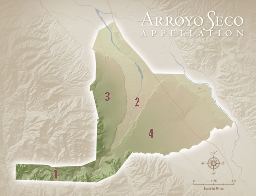
From west-to-east, the AVA features four general and visible areas of terrain - loosely referred to by local grape-growers as: (1) the "Gorge", (2) the "Ancient Riverbed", which cut (3) the "Western Bench" and (4) the "Southern Benchland". Each one of these general locations has various reasons why they are naturally self-limiting and ideal areas to grow complex and expressive wine grapes:
(1) The "Gorge" - this narrow ravine is protected from the direct marine-influences of the Pacific Ocean (and the southerly gale winds that plague the exposed, eastern segment of the appellation). That said, fog from the Pacific Ocean does penetrate the landscape and further the terrain is hampered by a strong easterly wind. Due to the dramatic rise of the mountains as well as millenniums of erosion, the soils are very shallow with a thin, rocky (shale-based) layer of topsoil. Furthermore, there is little flat, easily farm-able acreage and thus the steep terrain of the Santa Lucia Mountains constitute that vineyards be planted predominantly in mountainside locales. This portion of the AVA accounts for the area's highest elevations.
(2) The "Ancient Riverbed" - following the seasonal creek, this fanned landscape is bifurcated by benches (which the waterway cut) on either side as it heads towards the northern boundary of the AVA. Further, this section of terrain is directly exposed to the strong maritime influences that plague the Salinas Valley - an "open throat" valley which extends from the deep, cold waters of the Pacific Ocean. Due to its location, this portion of terrain experiences dense fogs and howling winds. It is further distinguished by meager soil conditions; river rocks litter the sandy surface-soil while dense, hardpan lens rests just feet below ground and promote root stress.
(3) The "Western Bench" - this portion of the appellation is visually defined by a 40-foot palisade that rises vertically from the "Ancient Riverbed" section on the western, mountainside of the AVA. Adjacent to the Santa Lucia Highlands AVA and overlooking the riverbed, the bench experiences the extreme marine-influences of the deep, cold waters from the Pacific Ocean at Monterey Bay. Fog saturates the landscape during the summer, ripening months and gale-force winds rack vineyard sites. Additionally, the western bench feature hillside like conditions whereby roots struggle to find water and thus further limit tonnage yields.
(4) The "Southern Benchland" - the bench and terrain located on the southern side of the riverbed which extends out south and east to the boarder of the appellation. This landscape features somewhat more fertile soil, yet the potential farming benefits are negated by converging winds; as the easterly wind from the "Gorge" combine with the southerly howlers from the Pacific Ocean. In addition to converging winds, the terrain is also the base of another smaller waterway - named "Reliz Creek" - and millenniums of erosion have covered this plain with a dichotomy of river-rock (shale and granite) in-and-among the topsoil.
All-in-all, each specific portion of terrain within the appellation features varying yet innately, self-limiting growing factors which in concert create a truly unique, complex and diverse American Viticultural Area (AVA).